


GeoStories combine interactive maps, media, and narrative. This collection contains all GeoStories from NG Education.
Via John Dalziel, Dorian Love
Get Started for FREE
Sign up with Facebook Sign up with X
I don't have a Facebook or a X account


 Your new post is loading...
 Your new post is loading...
Your new post is loading...
GeoStories combine interactive maps, media, and narrative. This collection contains all GeoStories from NG Education. Via John Dalziel, Dorian Love 
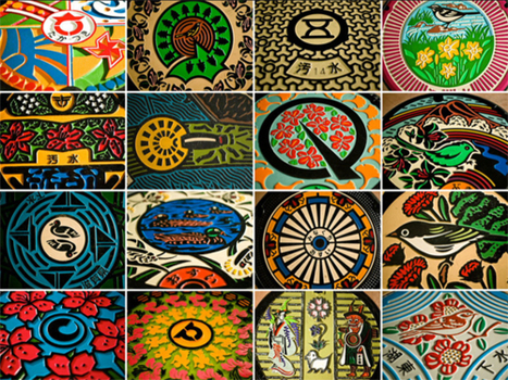
Manhole covers are a ubitquitous part of the urban fabric, and they are typically drab and purely utilitarian. In Japan, municipalities take pride in the this ordinary piece of the landscape and convert them into extraordinary works of art that reflect the local people, place and culture. Tags: book review, landscape, art, urban, culture, place.

Lauren Stahowiak's curator insight,
April 14, 2014 6:00 PM
This is a great take on art and the ways of celebrating Japan with touches of personal findings and ideas. These manhole covers are cheery and reflect a piece of Japan that not only tell stories, but embrace history. 
Kaitlin Young's curator insight,
December 12, 2014 3:17 PM
While many would consider it silly to turn something as ordinary as manhole covers into pieces of art, I believe that it is an amazing way to represent the culture of a place. Different townships and neighborhoods in Japan have distinct designs that relate to that place. This acts as an artistic expression of the characteristics of that place, since the designs are often chosen and designed by the people of that place. Some covers show historical events, animals, and even religious symbolism. I would love to flip through the book and try to imagine why each place chose each design. |

The National Geographic Word Atlas for 2013 is currently available as a free iPad app. I recommend grabbing it while it’s free. The app features a globe that students can rotate, zoom-in, and... Via Dr. Joan McGettigan

Dennis Richards's comment,
February 3, 2013 9:45 AM
Hope your students find it to be a useful tool for learning.
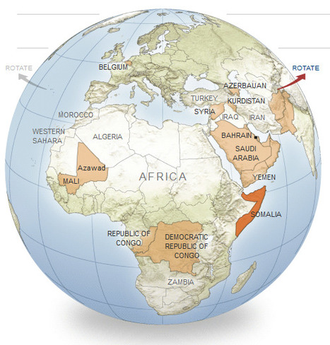
An interactive series of maps show possible new additions to the world’s list of independent nations.
This is great way to show examples of devolution and political instability. Included are 11 potential scenarios where further fragmentation/disintegration might occur or even greater regional integration that would redraw the map. These case studies include: Somalia, Korea, Azerbaijan, Belgium and the Arabian Gulf Union. Tags: political, devolution, supranationalism, war, autonomy, unit 4 political.

Anna Sasaki's curator insight,
March 24, 2015 8:53 AM
This article is probably one of my favorites I have read so far. It describes perfectly the political instability still present in the world, and that the globe and its boundaries are constantly changing, never staying put for too long. It surprised me at the new borders which most likely are going to happen, such as the unification of parts of Pakistan and Afghanistan. Also, the fact that South Korea is subtly getting ready for the reunification of North and South Korea. Also, there may be devolution in Mali and splintering devolution in the Congo's. This shows devolution as the power in these nations in which are breaking up, such as Belgium and the Flemish peoples. It shows the centrifugal forces behind the breakup of nations, such as ethnicities which vary, or the centripetal forces which bring nations together such as the combination of South and North Korea. 
Caroline Ivy's curator insight,
May 21, 2015 11:12 AM
Devolution/Fragmentation
This article is about nations that could become potentially independent in the near Future, whether due to chronic ethnic incoherence, redrawn governemnt policies, or a growing stateless nation group. Some examples given are an independent Khurdistan, a larger Azerbaijan, and the split of Belgium.
Centrifugal forces are the root of conflict in many countries. These forces include ethnic variety, lack of common language, political instability. These are what may be causing a split in both Belgium (developed country) and Somalia (developing country). There may also be a unification of countries—the map gives an example of the Saudia Arabia, Oman, Yemen, Bahrain, and other melding into one Arabian Gulf Union, of China absorbing Siberia. This does not necessarily herald the presence of centripetal forces, as these countries may be the result of military conquest.
|


GeoStories are published by National Geographic and contain a narrative, a map and media. It would be a great idea for students to make their own GeoStory about a significant historical character, ancient civilisation or a journey of discovery!